
At Upya, we are pioneering tools to help distributed renewable energy (DRE) providers manage complex, multi-regional operations. One of our standout innovations, Polygon zoning technology, offers a powerful solution for precise resource allocation and adaptable field operations. Designed for industries like agriculture, carbon credits, and renewable energy, this tool addresses the need for efficient field coordination.
Why Polygon Technology is a Vital Tool
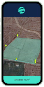
Field management over vast geographies can be challenging. To address this, Polygon zoning allows businesses to define specific zones on a digital map. As a result, companies can allocate resources more accurately, assign tasks within designated areas, and monitor field agent activities in real-time. Consequently, this improves operational efficiency, prevents double-counting, and supports data-driven decisions.
Key Benefits of Polygon Technology
 Efficient Data Collection: Field agents can capture GPS data, record geotagged photos or videos, and log precise measurements, even offline. Afterwards, this information seamlessly uploads to our platform, making it accessible for supervisors to review and refine as needed.
Enhanced Field Management: With Upya’s Polygon tool, supervisors can assign agents specific areas to monitor and verify that work remains within designated zones. Additionally, Geofencing ensures that commissions and task completions align with geographic requirements, bringing accountability and reliability to field operations.
Adaptability and Real-Time Control: Polygon zoning supports dynamic adjustments, enabling organizations to reallocate resources and reassign territories quickly in response to changing conditions. This flexibility is key for maintaining service consistency and optimizing resources across expansive territories.
Use Cases Across Industries
Agriculture: In agro-business, accurate land management is essential. The Polygon tool enables businesses to demarcate plots, track crop locations, and ensure efficient resource allocation for tasks like irrigation or harvesting. For end-users, this tool also brings transparency—such as tracing crop origins, which enhances credibility in products like fair-trade coffee.
Carbon Credits and Forestry: Polygon technology is highly valuable in forestry management, especially for carbon credit projects. It allows for precise monitoring of tree plots, tracks conservation progress, and documents tree growth within a plot of land over years or even decades. Polygon’s capability to support multi-year monitoring ensures data consistency, even with team changes over time.
Renewable Energy: For distributed renewable energy providers, zoning allows for efficient allocation of resources across off-grid installations, such as for mini-grid developers. Field agents can use the Polygon tool to map installation sites or coverage zones.
The Future of Zoning with Upya
Upya’s Polygon zoning technology provides a scalable, flexible solution tailored to the evolving needs of industries dependent on field management and data collection. As CRM systems advance, Polygon zoning will continue to reshape how businesses approach field operations, maximizing productivity, accountability, and adaptability. By offering a solution that integrates seamlessly with other modules like Task & Ticketing and Automations, Upya ensures that organizations are equipped for the complexities of modern, distributed work environments.
Our goal with Polygon is simple: to provide businesses with a tool that brings clarity, control, and efficiency to their operations, regardless of the field or region. As industries continue to adopt digital technologies, Polygon zoning stands out as an essential feature in driving sustainable, data-informed growth.
👉 Learn more about Upya’s Polygon Technology
📩 Contact us today for a demo!